Boundary Stones Before the Modern Map
Boundary stones reveal how old borders were marked on the ground; learn to trace their likely route without confusing a landmark with an official boundary.
Where did a boundary run before a printed map drew it as a line? Boundary stones can help answer that, but the marker itself may tell you less than the wall, track or stream around it. To trace a boundary stone’s likely route, follow the landscape as well as the stone.
A marker might have marked a parish, estate, common or another jurisdiction. Its meaning depends on its position and the records associated with it. The useful question is not simply what the stone says, but how a boundary was made legible to people moving through the place.
Boundary stones made divisions visible at useful points
A stone was a practical reference: something a landholder, parish officer or traveller could recognise on the ground. It might stand at a corner, beside a route or where a boundary crossed open land. The intervening line could follow a hedge or stream, so markers need not form a continuous chain.
That arrangement is different from the neat line on a modern map. A map records a boundary according to its purpose and conventions; a stone belongs to a particular spot in a working landscape. Reading one as a piece of local infrastructure, rather than a miniature legal document, helps explain why it may sit beside a path or wall without spelling out the whole division.
Read the landscape as a route between markers
Begin with a specific boundary: perhaps a parish edge, an estate limit or the margin of common land. Compare available maps from different periods, noting where the line follows a stream, ridge, track, hedge or wall. A map may suggest where to look, but a missing stone symbol does not establish that there was no marker.
On the ground, ask what would have made the line recognisable between stones. A wall may divide holdings; a stream may supply a natural edge; a track may run alongside a jurisdictional boundary without being part of it. These relationships can explain the route, but they do not make every nearby feature a boundary.
Plan a walk on public paths and record a few points along the suspected edge. Do not cross fences or enter closed land for a better view. It is not worth searching every hedge for a stone that may never have existed; a small number of well-situated markers can tell a clearer story than an unverified catalogue.
Record the marker’s setting, not just its face
From a public route, note whether the stone stands alone, sits in a wall, marks a corner or lies beside a track. Describe its shape, material, visible carving and condition without scraping, cleaning or moving it. If letters are unclear, copy only what you can see and mark doubtful characters as uncertain.
Take a close photograph of any inscription and a wider one that shows the setting. In your notes, include the date, nearby path or junction, the direction of the view and an approximate map position if available. A phone location may be imprecise near trees, buildings or steep ground, so do not make it look more exact than it is.
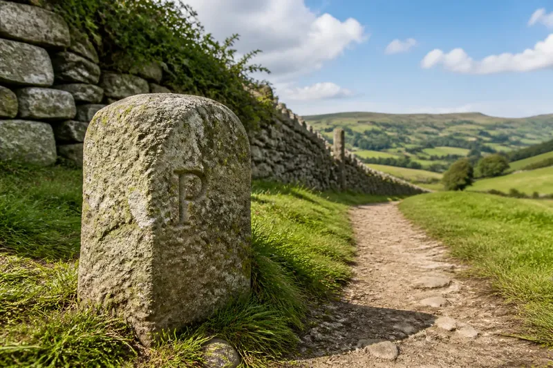
Say you find a squat stone beside a public footpath, with a faint initial and a dry-stone wall running towards it. You photograph the face and the wall, note the path junction, then compare the location with an old parish map. If the map shows a boundary following that wall, the likely route gains support; the initial alone still does not identify the division, and the stone’s position does not establish a legal line.
Separate the boundary’s route from the authority it marked
A parish, estate and common can meet or overlap in ways that look similar on the ground. A stone might mark ownership, administration or a local convention, and the same physical feature may have served more than one purpose. Maps, parish records and estate plans can help identify the relevant system, though their labels may describe an earlier arrangement.
Keep three questions distinct: where is the marker, what landscape feature does it relate to, and which boundary might it indicate? The first is an observation; the others require comparison. This distinction matters because a physical marker can remain after the boundary has changed, or be reused without retaining its original meaning.
For a clear record, use these prompts:
- Position: Note the nearest public path, junction or mapped feature. If the position is approximate, mark it as approximate; if you cannot locate it confidently, keep the route description instead of inventing precision.
- Marker: Describe the visible shape, material, inscription and condition. If a character is uncertain, record it as uncertain rather than expanding it into a name.
- Setting: Record whether the stone is beside a wall, hedge, stream, track or open ground. If the feature continues in a plausible direction, compare it with a map; if not, leave the connection unresolved.
- Alignment: Note whether other markers appear to line up or meet at a change of direction. If several fit the same mapped edge, treat that as supporting context; if they do not, consider that they may have different purposes.
- Map comparison: Check the point against maps from different periods. If the route remains consistent, record that agreement; if it shifts or is absent, preserve the difference rather than choosing the tidiest line.
- Interpretation: Write down what you can observe separately from what you infer. If records support a named boundary, cite the record in your notes; if they do not, describe the stone without assigning it a settled identity.
What can a boundary stone tell you?
Does every old stone mark a boundary?
No. A stone may have been reused, moved or placed for an unrelated purpose. A plausible position, inscription or pattern of markers can suggest a boundary, but compare those clues with maps and landscape features before drawing that conclusion.
What do carved letters or numbers mean?
They may refer to a parish, estate, owner, direction or local system, but a partial mark rarely explains itself. Copy the visible characters accurately and leave the meaning open unless a map or record supports a reading.
Can a stone show the exact boundary line?
Usually it identifies a point or general division, not the precise course between markers. The boundary may follow a wall, stream or surveyed line, so the stone’s position is evidence to compare rather than a legal determination.
What should I do if a marker is damaged?
Do not move, clean or repair it. Make a discreet record from a safe public place and contact the relevant local authority, land manager or heritage body if the damage seems significant; which organisation is appropriate depends on the site.
Maps and records explain what the stone cannot
At home, place the field notes beside the maps consulted before the walk. Check whether the marker lies near the mapped route, whether a wall or watercourse continues between points, and whether map editions show a change. If sources disagree, record the disagreement: a boundary may have shifted, or the maps may serve different purposes.
Parish records and estate plans can clarify which division a stone may have served, but a record’s label and a marker’s position answer different questions. Neither one automatically settles the other. For a legal or property dispute, use a qualified professional rather than treating a local-history interpretation as authoritative.
Boundary stones help make old divisions easier to recognise on foot. Their wider interest lies in the relationship between a fixed marker and the landscape route it once helped people follow. When the evidence leaves part of that route uncertain, leaving the gap visible is more useful than drawing a confident line through it.